
Jasper Wedge Uranium Project
- 100% interest in the Jasper Wedge Uranium Project, a highly prospective uranium project located within the prolific Athabasca Basin, Saskatchewan, Canada.
The Jasper Wedge Uranium Project (100%), MC0016116, covers an area of 2,099 hectares and is located within the prolific Athabasca Basin in northern Saskatchewan, approximately 45km south-east of the high-grade Cigar Lake uranium mine.
The eastern margin of the Athabasca Basin is tightly held, and the project is bordered by significant uranium mining and exploration companies including Cameco (TSX: CCO; NYSE: CCJ), Denison Mines Corp (TSX: DML; NYSE: DNN), Uranium Energy Corp (NYSE: UEC) and IsoEnergy Ltd (TSV: ISO).
The Jasper Wedge Uranium Project is considered to be prospective for unconformity hosted uranium mineralisation that is typical of the many large uranium deposits and active mines located within the Athabasca Basin (or the “Basin”), including the Cigar Lake uranium mine operated by Cameco1.
The Project is located approximately 30km from the eastern margin of the Athabasca Basin and is located in close proximity to regional highways and infrastructure.
The main uranium deposits in the area have mineralisation occurring at the unconformity located between the Maintou Falls Formation (conglomeratic sandstone) and the Wollaston metamorphic sequence. In the Cigar Lake area the prevailing structural framework is that of north-east – south-west lineaments2.
1https://www.cameco.com/businesses/uranium-operations/canada/cigar-lake
2The Cigar Lake uranium deposit: discovery and general characteristics. Uranium deposits of Canada (1986), Canadian Institute of Mining and Metallurgy, edited by E. L. Evans.

Jasper Wedge Uranium Project
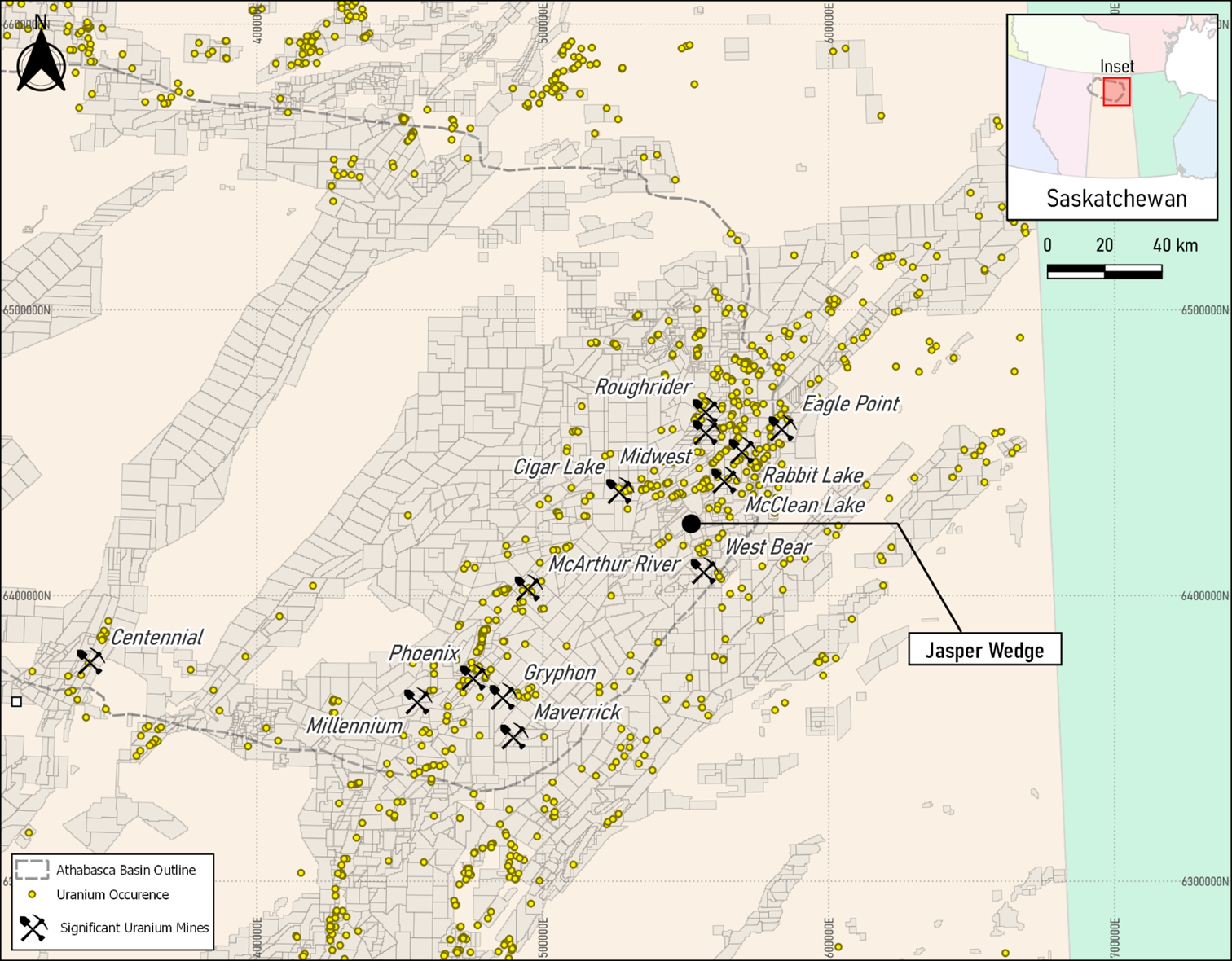
Jasper Wedge Project Location within eastern Athabasca Basin
Historical exploration data available includes airborne magnetics and electromagnetics (EM) over a significant proportion of the Project. The surveys were flown in 2008 for Denison Mines as part of a regional survey at 200m line spacing. Drilling completed in 1968 (Gulf Minerals) showed shallow depth to basement of between 78 and 104 metres. Basement rocks were logged as maroon to dark green granitic rocks with variable strong oxidation and local shear zones associated with heavy iron-stained fault gouge commonly occurring. Localised pyrite was also logged.
A NE-SW trending magnetic high feature (see Figure 3) underlies the majority of the Project that is in contact with a magnetic low feature at the eastern edge of the Project. An interpreted regionally significant NW-SE trending subtle cross-structure cuts through the entire northeastern part of the Project for a distance of 5km, which is in proximity to the magnetic high/low contact zone3.
This cross structure is likely to reflect potential discontinuity within the basement rocks that is perpendicular to the geological strike within the eastern part of the basin. These types of structures are of interest in uranium exploration in Saskatchewan as uranium-rich fluids often exploit a pre-existing structure within the basement rocks.
Additionally, there appears to be a NE-SW oriented conductor that is coincident with the various geological/geophysical features in the eastern portion of the Project.
Two diamond holes (6-3 and 6-4) were completed on the project by Gulf Minerals as part of a broader 6-hole programme in 1968. Although no assays were reported, details of the holes are below.
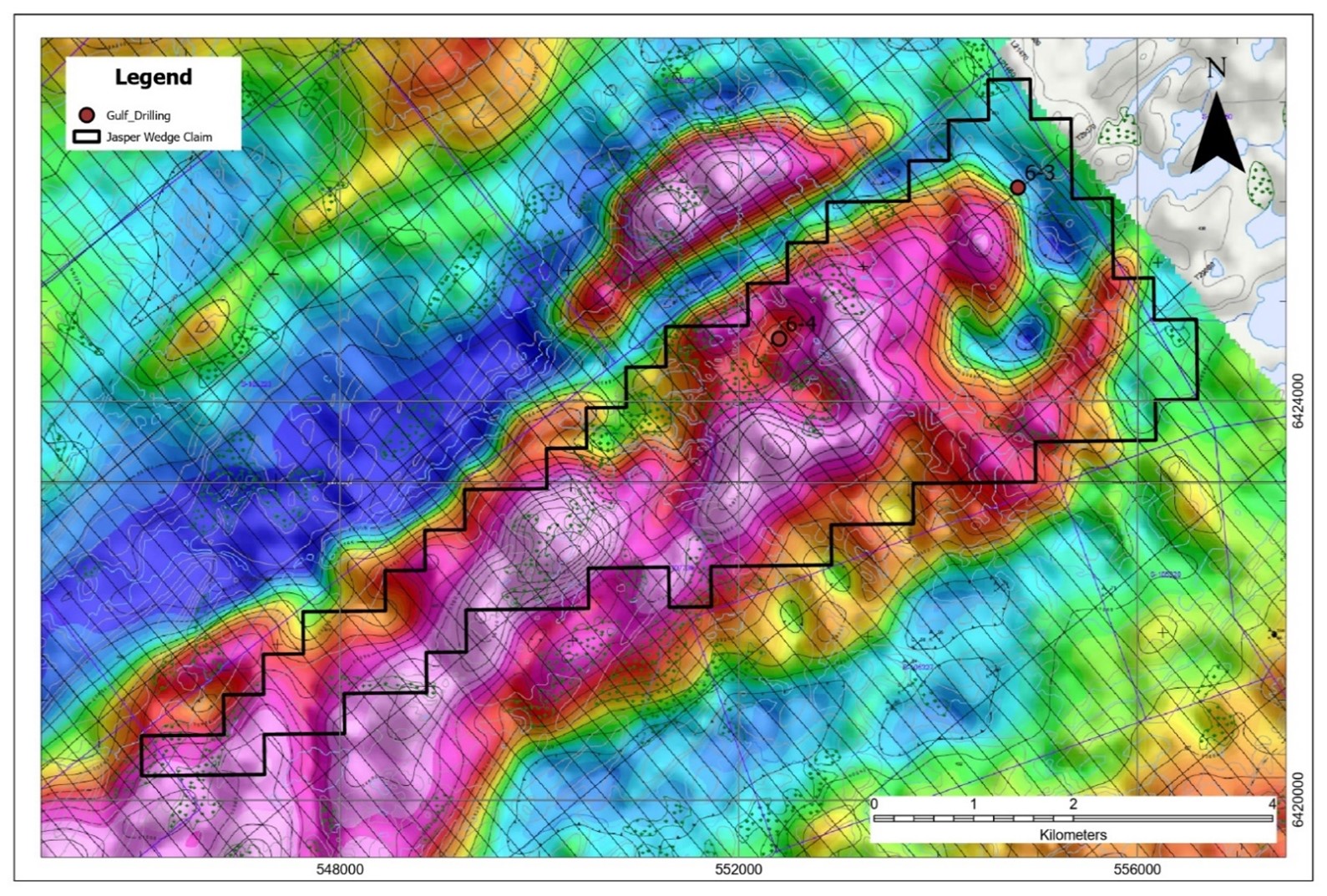
TMI Image over the Jasper Wedge Uranium Project
3Interpretation Report on a Helicopter-Borne AeroTEM System Electromagnetic & Magnetic Survey – Blocks Hidden Bay, Jasper Wedge, Moore and Patterson for Denison Mines by Aeroquest April 2008
Jasper Wedge Project 1968 DD Drilling (Gulf Minerals) Details (Sourced from Reference 64E13-0012)
| Hole ID | East | North | RL (Feet) |
RL (m) |
TD (Feet) |
TD (m) |
Dip | Azim |
| 6-1 | 553,872 | 6,417,970 | 1,487 | 453 | 455 | 139 | -90 | 0 |
| 6-2 | 561,578 | 6,420,184 | 1,445 | 440 | 452 | 138 | -90 | 0 |
| 6-3 | 554,797 | 6,426,148 | 1,500 | 457 | 381 | 116 | -90 | 0 |
| 6-4 | 552,402 | 6,424,631 | 1,590 | 485 | 410 | 125 | -90 | 0 |
| 6-5 | 549,258 | 6,431,550 | 1,609 | 490 | 510 | 155 | -90 | 0 |
| 6-6 | 558,641 | 6,425,120 | 1,439 | 439 | 232 | 71 | -90 | 0 |
Notes on Table: Hole coordinates converted from Latitude and Longitude to NAD83 Zone 13.
The Company plans to complete a more thorough review of the available historical exploration results, including reprocessing the available geophysical data.